4.7.2012 – Issue 6 - Middle East 1 – Ivanišin Krunoslav, Baumgartner Marianne – Essays, Videos
THE MOUNTAIN, THE RIVER AND THE HIGHWAY
by Marianne Baumgartner, "On the Road" Video by Krunoslav Ivanisin
And Moses went up from the plains of Moab to Mount Nebo, to the top of Pisgah, which is opposite Jericho. And The Lord showed him all the land, Gilead as far as Dan, all Naphtali, the land of Ephraim and Manasseh, all the land of Judah as far as the Western Sea, the Negeb, and the Plain, that is, the valley of Jericho the city of palm trees, as far as Zoar. And The Lord said to him, "This is the land of which I swore to Abraham, to Isaac, and to Jacob, 'I will give it to your descendants'. I have let you see it with your eyes, but you shall not go over there. (Deuteronomy 34:1-4 RSV)
Our view from Mount Nebo extends far over the hills and mountains, an expansive landscape, barren, apparently uninhabited. A plain opens to the south, where brown earth turns into damp gray mist. A few bright green patches here and there, geometrical fields with dark rows of trees pattern the countryside. Gentle hillocks contrast sharply with towering rock formations. Some dark spots in the distance hint at cities. Further down in the valley is Jericho, the city of palm trees, the lowest in the world, 250 metres below sea level. In fine weather, they say you can see as far as Ramallah, Bethlehem and Jerusalem.
This landscape will not have looked significantly different to Moses and his followers, over 2000 years ago. Deep down in the riverbed, the Jordan—now only a poor, overexploited trickle—probably brought more water into the valley back then, the historical source of flooding and of divine gardens. Several narrow winding streets on the opposite side of the valley, a few dotted cars and light-reflecting greenhouses present rather sketchy signs of modern times. Only poor constructions mark the spot where Moses stood or where John the Baptist preached. The rich, important history of religion and politics of this landscape lies deep beneath the surface of what is perceptible to the eye.
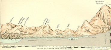
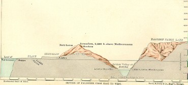
What we see from Mount Nebo is landscape. National maps and geology tell us the history of the Jordan Valley in their own language: the Jordan Valley is a depression running from north to south for approximately 150 km. It stretches from Lake Gennesaret (Lake Tiberias) in the north to the Dead Sea in the south. The valley takes its name from the river Jordan. The tributaries of the river Jordan rise in the Golan Heights, Mount Hermon in southern Lebanon and Tel Dan in Israel. After numerous meanders, the freshwater Jordan flows into the Dead Sea, a hypersaline endorheic lake. The river marks the course of the geological fault between the Arabian and the African plates, the Dead Sea Transform. As a result of the spreading of the Red Sea and the Gulf of Aden, the Arabian plate moves towards the north and northeast, and collides with the Eurasian plate, forming the Zagros fold belt. The sliding of the plates is responsible for the strong seismic activity in this area.
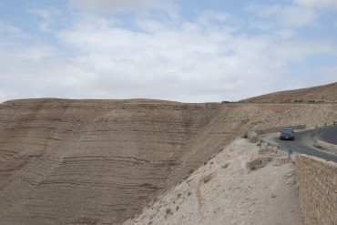
The river Jordan flows far below the terraces. Its furrowed bed of marl, typical badlands, is fragile. Only around Lake Tiberias and towards the Dead Sea does it become shallower and wider in section.
The river Jordan was the natural border between different peoples and kingdoms: between the Israelites and the Nabataeans in around the 6th Century BC, between Reubenites and Benjamites, between Judea and Perea, and, today, between Israel, the West Bank and Jordan. Land acquisitions across the Jordan were only successful short term.
Thus, since time immemorial, the Jordan valley has created a here and a there, a Cisjordan and a Transjordan, terms that manifest a very European view. The various nations of Jordan have used their own names to mark their land claims.
The only bridge that connects Jordan with the West Bank today bears names such as King Hussein Bridge or Allenby Bridge. Approximately every 30 years, this bridge is destroyed and rebuilt, and its use is strictly limited.
The Jordan is both the natural boundary of this area and the main artery for the people occupying both sides of the valley. Its waters supply the agricultural areas around Lake Tiberias. Around Lake Tiberias and westwards towards the Mediterranean, it enabled early agriculture, while providing drinking water for shepherds and nomadic tribes to the east. This gave rise to another conflict that continues today, even when canals and new agricultural technologies on both sides make the use of water more efficient.
The presence of its waters in an almost lunar landscape and its proximity to the King’s Highway, an important ancient trade route, gave rise to an enormous number of historical events. The vistas from Mount Nebo open up on a primeval landscape that has written rich pages in our history.
Download article as PDF


